|
|
 |
| |
| |
Gmina Trzebinia
Contact details:
Urząd Miasta w Trzebini
Piłsudskiego 14 street
32-540 Trzebinia
ph. 032 612 26 48, fax 612 11 47
e-mail: urzad@um.trzebinia.pl
www.trzebinia.pl
Contact person:
Barbara Skwarczek - Executive manager of European Integration Division, english language
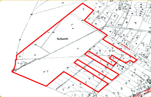
Land by A4 Highway in Salwator District
Location
Land (green field) located between A4 highway and Tuwima street (close to Chrzanów I junction).
Owner:
Gmina Trzebinia
Site
Area in m2: 270 000
Number of plots: 22
Other information
| Commercially available by: | sale of the estate or perpetual lease on the tender basis |
| Ground's destiny according to the local development plan: | The gmina area foreseen for services, restaurants, craftworks, production, and other commercial services - 15,5 ha. |
| Existing utilities: | The area is not fitted but there is possibility of plugging in sewage and water supply system, gas and electricity. Access to the estate form A4 highway through Chrzanów I junction, Długa street no. 79 and Tuwima street.
|
| Information about adjacent grounds: | The area is by plots not covered with buildings and open fields. |
| Available until: | without time limits |
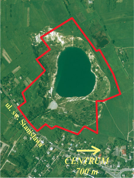
Recreation land with water reservoir "BALATON"
Location
Land is located by Św. Stanisława street, 700 m from square market. It is partially covered with warehouse and service buildings, car parks. In the centre there is a former stone mine filled with water which is used as summer swimming place.
Owner:
Gmina Trzebinia
Site
Area in m2: 142 239
Number of plots: 1
Other information
| Commercially available by: | rental or perpetual lease on the tender basis |
| Ground's destiny according to the local development plan: | The area is included in local space development plan, which marks this area for sport and recreation use with small shopping and restaurants connected with main use.
|
| Existing utilities: | The area is fitted in electricity, sewage system. There is road access to the area (road no. 79 Katowice - Kraków and then Św. Stanisława street).
|
| Information about adjacent grounds: | The area is surrounded by open fields from the north and by housing districts.
|
| Available until: | without time limits |
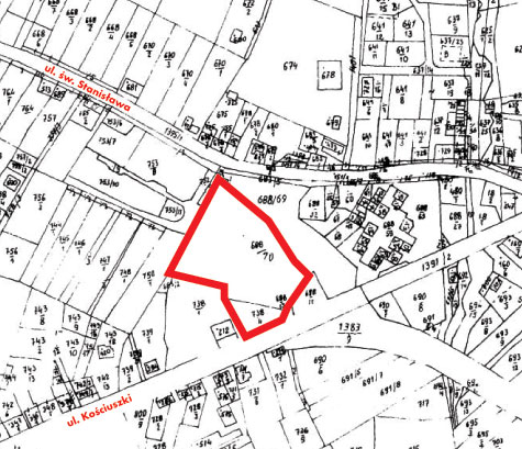
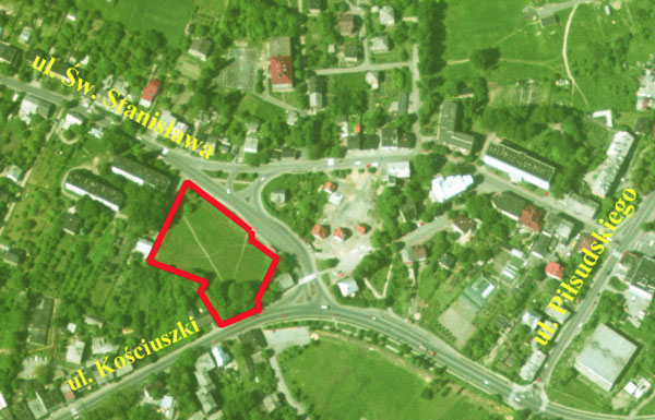
The area in the city centre by Św. Stanisława street
Location
The area is not covered with buildings, located in the city centre 400 m from the city square by the junction of Kościuszki street and Św. Stanisława street.
Owner:
Gmina Trzebinia
Site
Area in m2: 6 629
Number of plots: 2
Other information
| Commercially available by: | sale or perpetual lease on the tender basis |
| Ground's destiny according to the local development plan: | The area is included in local space development plan. The plan marks this area as used for housing and service activities.
|
| Existing utilities: | The area is fitted in electricity, sewage system. There is road access to the area (road no. 79 Katowice - Krakow and then Św. Stanisława street).
|
| Information about adjacent grounds: | The area is surrounded by housing districts and service providers.
|
| Available until: | without time limits |
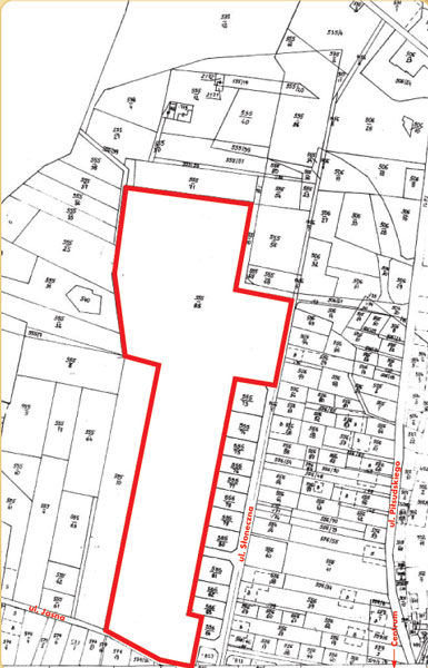
The area by Słoneczna street in Trzebinia
Location
The area is not covered with buildings, located by junction of Nowotki street and Słoneczna street 1 km from square market.
Owner:
Gmina Trzebinia
Site
Area in m2: 70 060
Number of plots: 1
Other information
| Commercially available by: | perpetual lease of particular plots on the tender basis |
| Ground's destiny according to the local development plan: | The existing plan of spatial development marks this area for housing and small service providers. Planned size of plots for housing varies from 400 to 1000 m2, and for housing and services no less than 2500 m2.
|
| Existing utilities: | The area is not fitted nearby water supply and electricity network. The access to the area consists of Piłsudksiego street (voivodship road no. 791) and then Nowotki street.
|
| Information about adjacent grounds: | The area borders with open fields from the north and west. From the south and east there are housing districts.
|
| Available until: | without time limits |
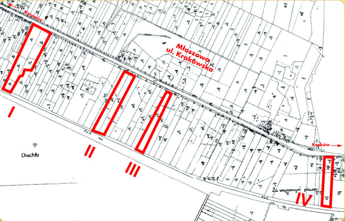
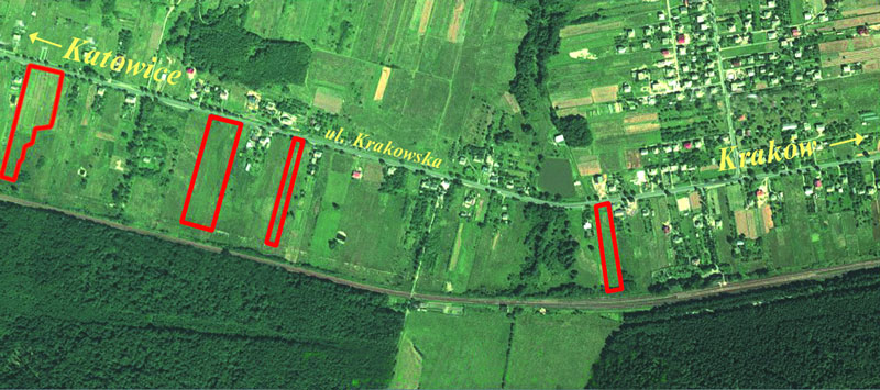
The areas on Młoszowa by Krakowska street
Location
The area is not covered with buildings, located by national road no. 79 Kraków- Katowice, consist of 4 fields.
Owner:
Gmina Trzebinia
Site
Area in m2: 44 082
Number of plots: 10
including:
field I - 5 plots - 15 401 m2
field II - 2 plots - 16 292 m2
field III - 1 plots - 6 628 m2
field IV - 2 plots - 5 761 m2
Other information
| Commercially available by: | sale or perpetual lease on the tender basis |
| Ground's destiny according to the local development plan: | There is no spatial development plan for field IV. For fields I, II, III there is a need for preparation of spatial development plan.
|
| Existing utilities: | The area is located closely to water supply, electricity and gas network. There is a road access from national road no. 79 Kraków - Katowice.
|
| Information about adjacent grounds: | The area borders with housing plot from the east, and uncovered plot from the west. Fields I, II, III border with uncovered plots.
|
| Available until: | without time limits |
|
|
|